
Shorter winters increase risk for tornadoes like the one that hit Garner, NC. Here’s why
The temperature was an unseasonably warm 65 degrees Fahrenheit when an EF-1 tornado touched down in Garner on Sunday, according to N.C. State Climate Office data.
That’s nearly 20 degrees warmer than the 47.7 degree Fahrenheit average temperature recorded over the last 29 years at the Climate Office’s Lake Wheeler Road Field Lab station.
And it raises questions about whether winter warmer temperatures, particularly in early December and late February, could be increasing the likelihood of tornadoes.
Corey Davis, the Climate Office’s assistant state climatologist, said there has been an uptick in storms during those “shoulder weeks” when warm air and cold air are coming together, conditions that help tornadoes form.
What happened with tornado in Garner, NC?
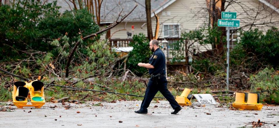
The tornado touched down near Old Stage Road at 12:28 p.m. Sunday, according to the National Weather Service. It covered about 1.5 miles over the next four minutes as it traveled northeast.
Winds from the storm snapped and uprooted trees along its path. A News & Observer photographer captured images of trees toppled onto houses and at least one of a branch that had been punched into a wall.
In total, 21 homes were damaged, a Town of Garner spokesman said Monday. Rick Mercier, the spokesman, said in an email that four of those homes are uninhabitable, two are partially uninhabitable and four other suffered major damage.
The storm lifted off the ground again near Garner Magnet High School.
A tornado touched down in Garner. Here are photos from the destruction and cleanup
What conditions led to the tornado?
A cold front moved in behind the warm temperatures that were already in place Sunday, creating the updrafts that build thunderstorm clouds.
That warm air, which acts as fuel for tornadoes, was the “first clue” Sunday that conditions were unseasonable, Davis told The N&O.
“It’s historically pretty unusual to get temperatures that warm during the winter months,” Davis said.
Once the warm air is rising, it needs wind shear — or wind that is changing directions in the atmosphere — to develop the rotation.
All of those things happened on Sunday.
Are winter tornadoes becoming more common?
Climatological winter covers December, January and February.
In North Carolina, there have been 109 tornadoes in climatological winter since 1950, or about 15 per decade.
That’s increased slightly over the last two years, when Davis said North Carolina averaged 13.8 storms per decade. Much of that comes from a February 2020 outbreak that saw eight tornadoes in a single day.
This year, there have been three winter tornadoes, with two in January and the one in Garner on Dec. 10.
The Garner storm is indicative of another potential trend, where shorter winters could mean more potential for severe weather in early December or late February.
From 1950 to 2019, North Carolina saw 46 tornadoes in the first two weeks of December or the last two weeks of February, about 6.6 per decade. Then the period from 2010 to 2019 saw 12 such storms.
Over the last 10 years, there have been 13 tornadoes in those weeks at the beginning and end of winter, including Sunday’s tornado. Much of that is driven by a Feb. 24, 2016, outbreak that saw tornadoes drop down across the state’s coastal plain.
“The basic setup that we had yesterday would be very common to have in the spring, where we would expect to have that type of activity,” Davis said. “It’s usually not as common to happen here in the middle of December.”

Is climate change making severe weather conditions more likely?
Warmer temperatures lead to more risk for severe weather, Davis said. And climate change is shortening the length of winter, leaving a fall-like warmth later and bringing spring thaws earlier.
“The period when we’re seeing those winter-like temperatures is not three months anymore,” Davis said. “We might start to look at late December through early February as when it’s most common to get those winter-like temperatures.”
That means there is more time where warm and cold conditions can collide, coming together to potentially create a tornado.
“In events like yesterday’s, it’s still easy to pick out the contribution of an almost spring-like weather pattern happening during the winter, which is very much in line with our warming trend, particularly at this time of year,” Davis said.
Has NC experienced other winter tornadoes recently?
Yes, in 2021 an EF-3 tornado hit Brunswick County with its 160 mph winds. The storm killed three people and injured 10 more.
The Feb. 24, 2016, line of thunderstorms caused minor damage in North Carolina, but the same storm created tornadoes that killed three people in southeastern Virginia, according to the National Weather Service.
This story was produced with financial support from the Hartfield Foundation and 1Earth Fund, in partnership with Journalism Funding Partners, as part of an independent journalism fellowship program. The N&O maintains full editorial control of the work.

