
Snow chances aren't over in southern Ontario despite early signs of spring

For southern Ontarians who chose to 'staycation' this March Break, the weather has certainly been on your side in terms of temperatures. A double-digit warm-up saw daytime highs soar into the 20s on Wednesday, with the milder and well above seasonal conditions even hanging even through the rain that rolled through on Thursday.
Despite being just days away from the official start to spring on Tuesday, winter certainly won't go out without a fight across the region, with widespread cooler temperatures and snow chances creeping in throughout the weekend and beyond.
DON'T MISS: Everything you need to know for April's spectacular and rare solar eclipse
A national pattern flip will see those colder conditions hang on through the end of March, as well, so be sure to keep the winter gear near by, and prepare to adjust to the changing conditions. It may even be a good idea to keep those winter tires on for now.
Although temperatures will still be changeable as the month comes to a close, it is unlikely that we will see temperatures as warm as what we saw this week for the next few weeks, at least.
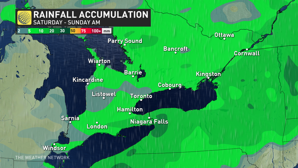
Saturday: Snow to the north, and rain to the south
After another calm and above seasonal day on Friday, conditions will become more unsettled as we make our way through this last full weekend of winter.

A cross-country clipper system will see flurries develop across parts of northern and central Ontario to start the day Saturday before transitioning to scattered rain showers as temperatures warm just above the freezing mark.
Increasing clouds will build across the south, with periods of rain likely Saturday and into Sunday, though not a washout with less than 5 mm expected.
RELATED:
Sunday: Much cooler temperatures start to funnel into southern Ontario with risk of snow
By Sunday, temperatures will cool significantly with the passing of a cold front, with the risk of snow flurries across central Ontario and areas near Lake Huron and Georgian Bay.
Some rain and mixed precipitation is more likely for places along Lake Ontario and Lake Erie.
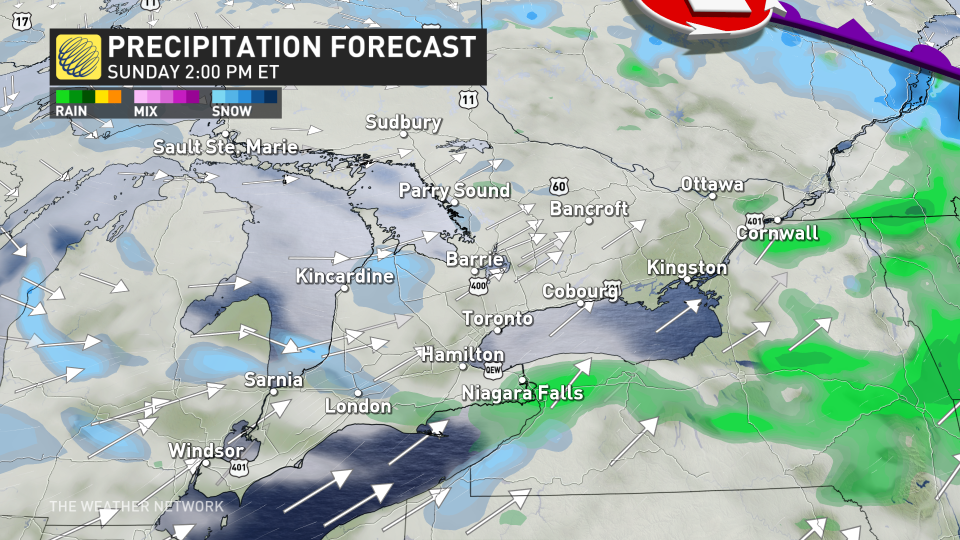
While there is still very low confidence for exact snowfall totals and placement over the Great Lakes, the cooling temperatures and unsettled weather that follows is more of a guarantee. That means winter travel isn't over, and drivers will need to prepare to adapt to the changing conditions.
RELATED: St. Patrick's Day green traditions linked to these weather patterns
Monday: Burst of flurries moves through, colder weather hangs on
As the colder air settles in, more widespread flurries with bands of lake-effect snow are likely to develop southeast of Lake Huron and Georgian Bay. There could be brief periods of reduced visibility through the morning hours.
These lake-effect bands will continue into Tuesday and temperatures will be a few degrees cooler than seasonal.

The long-range pattern supports a deep trough in Eastern Canada, while ridging occurs in the West. This will mean much more seasonal air hangs on for mid to late March, with an active pattern setting up, as well. There's the potential for some messy and wintry systems of parts of the region, though it's too early to have confidence in the storm tracks and impacts. Across the south, there's better chance for rain with these systems.
Stay with The Weather Network on all platforms for the latest details on your forecast across Ontario.

