
Southern US to be soaked by needed rain at the expense of tornadoes
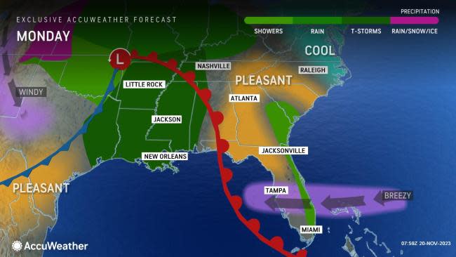


A large storm that threatens to create travel chaos across the eastern third of the nation in the days leading up to Thanksgiving will be a bittersweet blessing for portions of the South, where AccuWeather meteorologists say that beneficial rain may arrive with dangerous and damaging consequences due to potentially violent thunderstorms.
The upcoming weather pattern will mark the first risk of severe thunderstorms since September for some locations from the southern Plains to the lower Mississippi Valley and Southeast.
Where severe weather does not occur, the rain will be good news for the ongoing drought but ill-timed with some of the busiest travel days of the year prior to Thanksgiving.
The storm being tracked by AccuWeather meteorologists has origins from the Pacific Ocean, where it has lurked off the coast of California for days this past week. As the storm sweeps eastward across the country and gathers moisture from the Gulf of Mexico and even the southern Atlantic Ocean, the expanse of rain and the intensity of thunderstorms that it produces will increase.
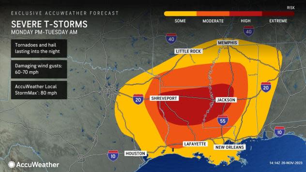
AccuWeather forecasters say that Monday and Tuesday will pose an even higher risk for dangerous thunderstorms, in terms of the number of reports and severity of the expected hazards.
"The severe weather threat will push eastward into the Arklatex region and lower Mississippi Valley later Monday into Monday night," AccuWeather Senior Meteorologist Dan Pydynowski said.
Residents in Shreveport, Louisiana, Little Rock, Arkansas, Jackson, Mississippi, and even the northeast side of the Houston metropolitan area will need to be on heightened alert during the daylight hours Monday before the conglomerate of thunderstorms races eastward heading into the overnight hours.
 |
"There will be some limiting factors in the atmosphere that may hinder the development of tornadoes in the first place," AccuWeather Senior Meteorologist Alex Sosnowski said, adding, "But, should these conditions be overcome, the situation could escalate quickly to more of an outbreak that includes some strong tornadoes."
"Across much of Mississippi and southeastern Louisiana, given the speed of the storm, much of the severe weather threat will occur at night. Severe storms crossing these areas Monday night can include tornadoes in addition to hail and wind," Pydynowski said.
"Nocturnal tornadoes are even more dangerous as they usually cannot be seen as they approach an area and people are often sleeping when they strike," Pydynowski added.
Have the app? Unlock AccuWeather Alerts™ with Premium+
The zone from just south of Memphis, Tennessee, to Jackson, Mississippi, and Baton Rouge, Louisiana, will face the highest threat of severe weather dangers after dark on Monday.
"Everyone should be weather ready and have their NOAA weather radio turned on to stay safe at night as well as have alerts and notifications activated on their AccuWeather app," Pydynowski said.
 |
By Monday night, rain, gusty winds and wintry conditions will spread across portions of the Great Lakes region before shifting across the Northeast on Tuesday as thundery downpours continue to sweep through the South, impacting places such as Atlanta.
Air travel can come to a standstill for a time at the major airport hub until the rain and thunderstorms have safely passed. Ripple-effect delays are likely elsewhere across the nation if aircraft and crews are displaced due to the weather in the Southeast.
Downpours, hail and damaging winds can extend as far east as portions of South Carolina as well as southward into the Florida Panhandle Tuesday into Tuesday evening.
 |
Over the course of the two days, motorists will need to be wary of any downed tree limbs or other debris that may litter the roadway during and in the wake of the storms.
As of the latest outlook from the United States Drought Monitor from mid-November, drought conditions are expansive throughout the southern tier of the country. Exceptional drought, the highest tier on the intensity scale, is impacting nearly 75% of Louisiana and 50% of Mississippi.
 |
Between 1-3 inches of rain can fall over these areas over the course of several hours early this week, with locally higher amounts possible in the most intense thunderstorms.
A soaking rain is likely throughout the South even in areas that do not get hit with severe weather, such as in Tennessee and into the southern Appalachians, where long-term dryness also exists.
Motorists in the zone between I-10 and I-40 are urged to slow down in the downpours as visibility will be reduced from road spray and the risk of hydroplaning will increase.
By Thanksgiving Day, the risk for severe weather will have ended across the South. While odds favor a mainly dry holiday for the region, AccuWeather meteorologists will be closely monitoring the potential for moisture to return by the last weekend of November.
Want next-level safety, ad-free? Unlock advanced, hyperlocal severe weather alerts when you subscribe to Premium+ on the AccuWeather app. AccuWeather Alerts™ are prompted by our expert meteorologists who monitor and analyze dangerous weather risks 24/7 to keep you and your family safer.
