
Storm threat elevated in southern Ontario as heat, humidity rises
After a couple days of frost risk during the week, conditions have warmed up considerably since then, with even humidity making a return this weekend.
That sounds like the recipe for the perfect weekend, but there's a caveat. A system that pushed into the northern Great Lakes will also bring rain and a risk of thunderstorms alongside the summer-like warmth and humidity that covers parts of the region.
PHOTOS: Highway camera captures stunning tornado on the horizon
It is the first of two systems, so the risk for foul weather will continue on Sunday, as well. Some areas could see a threat for severe storms Saturday evening and overnight, so make sure you stay weather-aware and alert.
Large hail, heavy rainfall and strong wind gusts will be the main threats. However, if the cold front arrives sooner than expected, the environment will be better suited for rotating storms to develop in areas near Sudbury, Manitoulin Island and the Bruce Peninsula. But, there is uncertainty.
Storms possible on Saturday, severe potential for some areas
After a chilly end to the week, warmer winds blowing in from the south will allow temperatures to rebound closer to normal for the day on Saturday. A hint of things to come will creep into far southwestern Ontario, though, where readings should come in above-seasonal.
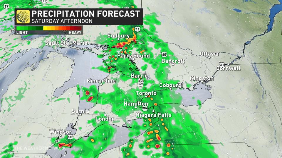
A system tracked north into the northern Great Lakes Saturday morning, bringing a warm air mass with it. Rain and possibly a few embedded thunderstorms will spread into southern Ontario as the day progresses.
We’ll see a break in the precipitation develop for the Greater Toronto Area and areas southwest heading into Saturday afternoon as the rain pushes off toward the National Capital Region by the evening hours.
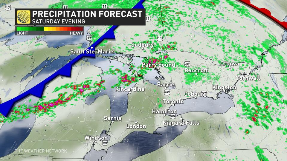
A second round of rain and thunderstorms will arrive late Saturday night into early Sunday morning as a cold front advances out of northern Ontario.
We’ll see a risk for thunderstorms along and ahead of the cold front throughout the Nickel Belt and into sections of cottage country.
Timing of the front will be paramount in severe thunderstorm potential.
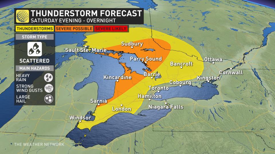
Some of the storms around Sudbury, Parry Sound, and down toward the Bruce Peninsula could approach severe limits with heavy rainfall, strong wind gusts, and small hail.
If the front speeds up, however, thunderstorms will have a better environment for rotating storms along with large hail. That may be the case in areas near Sudbury, Manitoulin Island and the Bruce Peninsula, but there is uncertainty.
Early-summer tease arrives Sunday
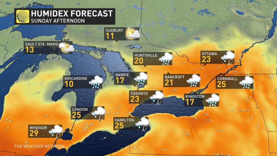
Sunday could be the warmest day of the year for much of southern Ontario as this May-like pattern arrives to end the weekend, although scattered showers and a thunderstorm risk could put a brief damper on the afternoon.
The warmest readings we’ve seen so far this year include:
26.1°C in Windsor on April 14
23.8°C in Hamilton on April 9
20.6°C in Toronto on March 13
19.9°C in London on April 14
YYZ with a forecast of 21C up against March 13th’s 20.6C Windsor’s forecast 24C up against April 14 26.1C London’s forecast 22C up against April 14 19.9C YHM’s forecast 22C up against april 9 23.8C
Daytime highs on Sunday will soar into the mid-20s for many communities, with humidex values possibly cracking 30 around Windsor.
Given the warmth in the forecast, Toronto and London are on track to beat 2024’s high-mercury mark by Sunday, while Hamilton might fall short by just a hair.
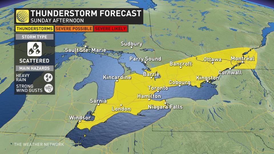
We’ll see a renewed risk for showers and thunderstorms over southern Ontario during the day Sunday as this warm and unstable air builds in. This includes much of the Highway 401 corridor from Windsor to Kingston, including Toronto, as well as north toward Bancroft and Barrie. Look out for heavy rain and gusty winds in any of the feistier storms that bubble up on Sunday.
Warmth sticks around into early next week
Another rainy system tracking into northern and central Ontario on Monday will keep the unseasonably warm air parked over the southern half of the province to start the week. However, there’s uncertainty in just how warm things will get on Monday. We could see big temperature variations over short distances with clouds and lake breezes.
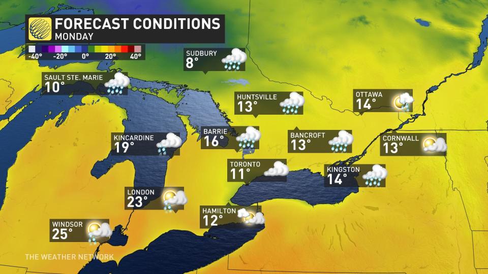
We’ll see additional showers and possibly a risk for rumbles of thunder as that disturbance passes the region to the west.
Temperatures will likely start to moderate back toward seasonal as we head into the second half of the upcoming week. Warm-weather lovers may not have to wait long for above-seasonal conditions to return, as more unseasonable warmth could arrive in time for the beginning of May.
Stay with The Weather Network for all the latest on your forecast across Ontario.

