
Storms with hail, lightning will be back in Dallas-Fort Worth. Meanwhile, expect frost
Thunderstorms are expected back in Dallas-Fort Worth by Wednesday or Thursday bringing hail and lightning but nowhere close to the severity of the weather that hit the region late last week, according to the National Weather Service Fort Worth office.
In the meantime, enjoy the sunny spring weather to start the week. Expect temperatures to drop across North Texas overnight Monday due to radiational cooling with many areas, especially to the east of I-45 and north of I-30, will wake up to patchy frost.
“The persistent closed upper low over the Southwest U.S. will open up over the southern Rockies on Wednesday. Showers and thunderstorms will be possible across North and Central Texas late Wednesday and Thursday as the upper trough (and associated surface low/Pacific front) shift across the Central and Southern Plains,” writes Fort Worth meteorologist Eric Martello on the NWS website.
⚡ More trending stories:
→ There’s no ‘better place’ to see April 8 total solar eclipse than in this tiny Texas town.
→ How a six-pack of beer, $100 got rescuers to pull pig out of thorns.
→When do tornadoes occur the most in Dallas-Fort Worth?
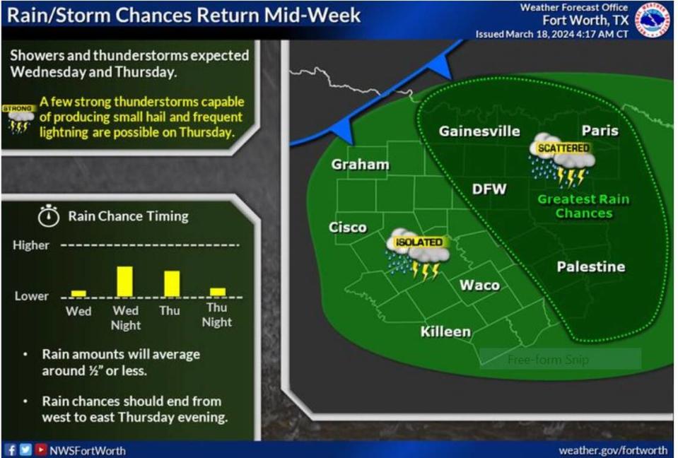
Closed upper lows can bring unsettled weather, including cloudiness, precipitation, and sometimes severe storms, as they move across a region. Rainfall is most likely to occur late Wednesday and into Thursday, with the potential for storms growing throughout the day.
“Thunderstorm potential will increase during the day Thursday as the atmosphere destabilizes, a few of which may become strong enough to produce small hail and frequent lightning,” the NWS forecast states.
Tuesday morning will be the coldest day of the week with temperatures in the mid to high 30s.
“This will be the chilliest morning of the week. Radiational cooling will be in full force and will combine with very low humidity for low temperatures tanking into the 30s, with a few readings remaining around 40 degrees for especially the immediate urban areas,” Martello writes. “More widespread frost is expected along and northeast of a Gainesville, to McKinney, to Kaufman/Canton line, so you’ll need to cover, or move inside any sensitive plants or flowers.”
Texas is heading into its season of severe weather when tornadoes occur the most. The weather service warns residents to be weather aware and know what to do when a tornado warning is sent.
The good news is that wildflowers are beginning to bloom. Bluebonnets have been spotted along North Texas highways in the past few days. Now would be a good time to plan for a road trip to see the blooms.

