
NC temperatures have hit the dangerous level. How long will it last?
Temperatures climbed into the mid-90s on Saturday, reaching a dangerous level that the National Weather Service says is not likely to let up for days.
Forecasters are predicting heat indexes between 100 and 105 degrees Fahrenheit across the Triangle through Sunday, with heat indexes in some parts of the region reaching as high as 108 degrees. Heat index uses temperature and humidity to measure what conditions feel like for the human body.
Temperatures will be in the mid- to upper 90s for most of next week, according to the NWS. Low temperatures on both Sunday and Monday are forecast to hover around 75, a level at which an expert previously told The News & Observer the body will struggle to recover from heat impacts.
Monday’s high temperature is forecast to reach 95 degrees, with an afternoon heat index around and slightly above 100 degrees.

The NWS expects highs in the mid- to upper 90s on Wednesday and Thursday. Humidity levels will increase around the same time, according to forecasts, with heat indexes between 100 and 104 degrees around and east of Cary and Raleigh.
Much of North Carolina could see excessive heat risk Thursday and Friday, according to the NWS’ Climate Prediction Center. There is a more than 40% chance that heat indexes will exceed 105 degrees Fahrenheit in the risk area that includes central North Carolina those days, according to one model NWS uses.
To stay safe during a heat wave, experts recommend steps like avoiding strenuous outdoor activity in the hottest parts of the day, making sure to drink plenty of water and finding a public place with air conditioning if it is not available at home.

Drought risk, too
Another risk across most of the state is rapid onset drought. Central North Carolina westward to about Asheville are part of a region stretching from northern South Carolina to southern Pennsylvania that could see drought set in over the next two weeks, according to the NWS map.
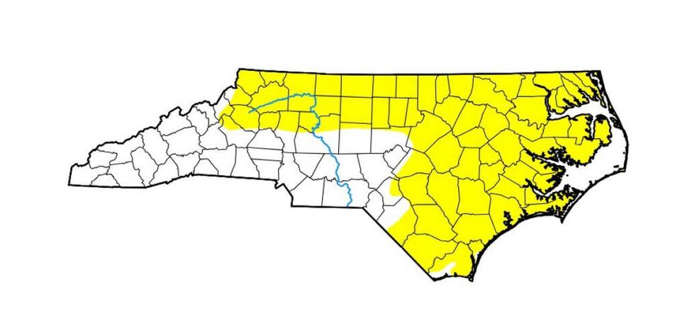
Right now, 65% of North Carolina is abnormally dry, according to the U.S. Drought Monitor. That includes effectively everywhere from Wake County east and from Durham County north, west to Caldwell County.
There’s already impacts across the state, with farmers in Martin and Washington counties reporting that their corn crops are suffering from the heat and in need of rain, streams in the southeastern part of the state running at extremely low levels and wildfire risk increasing.
“Without significant rainfall, degradation is likely to continue with widespread drought impacts possible as we enter July,” the NWS’ Raleigh office posted in a message on X.
This story was produced with financial support from the Hartfield Foundation and Green South Foundation, in partnership with Journalism Funding Partners, as part of an independent journalism fellowship program. The N&O maintains full editorial control of the work. If you would like to help support local journalism, please consider signing up for a digital subscription, which you can do here.

