
Thunderstorm risk kicks off unsettled weekend in Ontario and Quebec
Temperatures in Ontario and Quebec have been giving people a taste of the summer to come as temperatures rise and humidity builds.
When it comes to hot, muggy days, it's only a matter of time before thunderstorms start to roll. Many folks in Ontario were treated to a late-night storm on Wednesday, with some showers in southern Ontario lingering into the early morning hours on Thursday.
With the heat and humidity, comes a building thunderstorm risk across both provinces and a growing forest fire threat in Quebec.
SUMMER 2024: Get an in-depth look at the Summer Forecast, tips to plan for it, and much more!
A low-pressure system will settle over Ontario on Thursday, bringing bouts of unsettled weather, including the risk of additional thunderstorms. A storm severe risk exists in parts of eastern Ontario and Quebec on Thursday.
Be sure to stay up-to-date on all of the weather alerts in your area, especially with the growing thunderstorm chances as we inch even closer to the official start of summer this month.
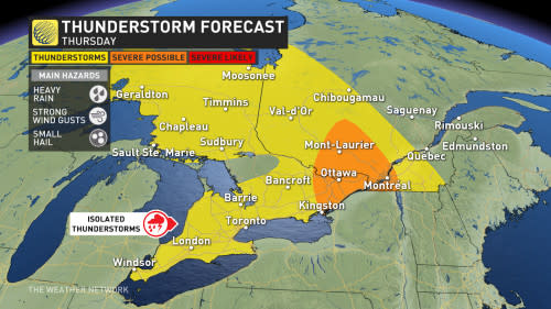
Thursday: Thunderstorm risk continues for eastern Ontario and Quebec
The low-pressure system will position itself over Ontario from Thursday to Sunday, bringing bouts of unsettled weather, including the risk of thunderstorms.
A line of thunderstorms will track into eastern Ontario and western Quebec on Thursday, bringing persistent rainfall to the regions throughout the day. Southern Quebec will also be seeing these storms and rain, but will have to wait until the late afternoon and overnight hours.

With the high humidity over the regions, ample amounts of moisture are available for these storms to tap into. As a result, the main threat with these storms will be heavy rainfall. Localized flooding is also possible, as some areas could receive 30-50 mm of rain.
A risk for severe storms lies in parts of eastern Ontario and southern Quebec on Thursday. In addition to heavy rains and localized flooding as the main risks, severe storms could also produce strong wind gusts and up to nickel-sized hail.
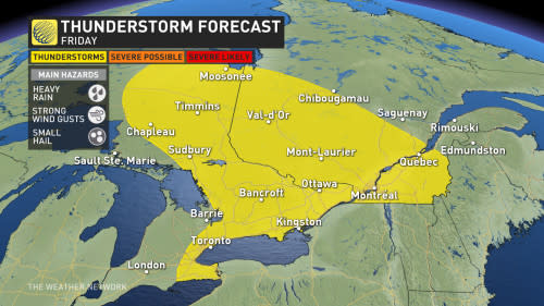
Friday and through the weekend: Rain persists with unsettled conditions
Unsettled conditions are likely to continue into the weekend for most of Ontario and Quebec, with showers lingering through Sunday.
A widespread thunderstorm risk will still remain over most of Ontario and and Quebec on Friday, but are unlikely to reach severe strength.
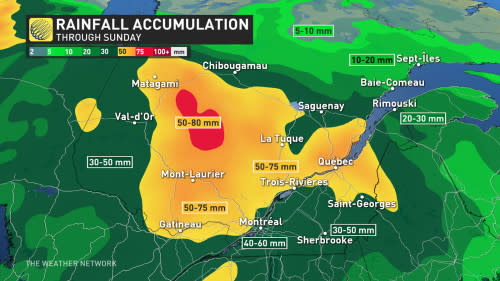
By the end of the weekend, some folks across southern Quebec could see 40-80 mm of rain fall. With Thursday and Friday's storm risks, up to 100 mm of rain is possible, locally.
Localized flooding will continue to be a risk over the weekend, however the heavy rain will be a welcome scene for wildfire-prone regions in Quebec.
This unsettled pattern should linger over southern Quebec through the next week as well. While there will be some rain-free periods and even peeks of sun, as well, temperatures will be a few degrees cooler than seasonal, and some areas may even struggle to top 20°C when little sunshine is present.
Temperatures will likely be below seasonal by about 5°C across southern and eastern Ontario on Saturday, with cooler troughing overhead. The province's hot spot will likely be near James Bay as daytime highs soar into the low- to mid-20s.
Conditions will remain cooler for the second half of next week, lasting into Father's Day weekend. A warmer pattern will return during late June.
Be sure to check back for the latest weather updates across Ontario and Quebec.

