
‘Very large hail’ possible with storms headed for Dallas-Fort Worth. Here’s what to know
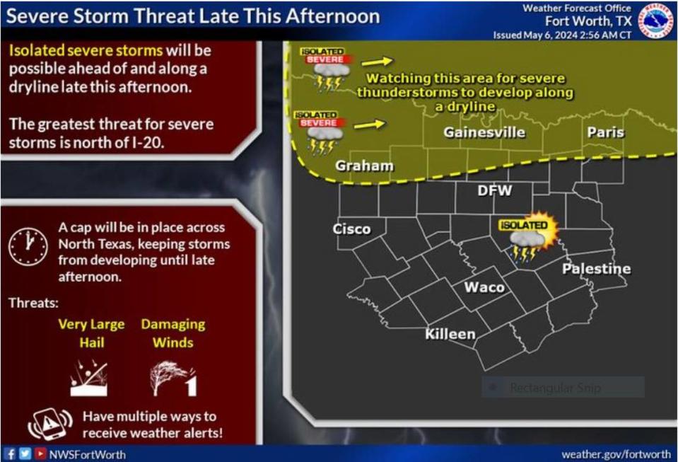
Any storm that forms today in the Dallas-Fort Worth area can turn severe with “very large hail,” strong gusty winds and even possible tornadoes — although this is “a more tertiary threat” — according to a National Weather Service Fort Worth report early Monday morning.
When the inclement weather arrives depend on when a cap of warm air above North Texas breaks up. The presence of this lid can increase the potential instability of warm air below it and the cool air above it, which means expect severe weather when it finally lifts.
“The main threats for today will be large to very large hail and damaging winds. There is an attendant tornado threat, especially with the more discrete storms, but low level [changes in wind speed] magnitude is marginal to keep this a more tertiary threat,” Fort Worth meteorologist Allison Prater writes on the NWS website. “Overall, the severe threat for our area remains highest generally north of I-20, though Oklahoma has the greatest threat of the day.”
⚡ More trending stories:
→Snakes are crawling out of hibernation in Texas. Check the toilet before taking a seat.
→Can Texans drive home with legal weed bought in California? Here's what the law says.
→A Fort Worth neighborhood was a food desert. Then an ex-Dallas Cowboys linebacker moved in
But even before the new line of storms arrive in our area, the weather service says we could see some rain. With the severe storms that blew through North Texas over the weekend, many areas are still waterlogged with much of the region in a flood watch Sunday.
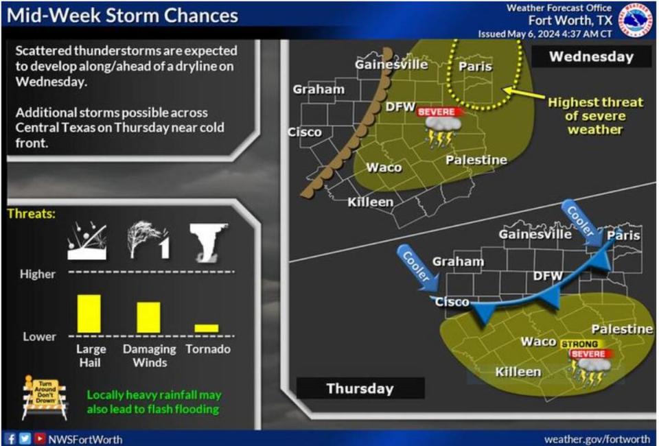
A cold front will blow through the region by Tuesday morning, pushing much of the bad weather to the east, Prater said. Temperatures by the afternoon will peak in the high 80s, and even 90 degrees.
With the heat comes more chances of thunderstorms. The cold front mixed with an approaching dry line may mean more bad weather.
“Strong to severe thunderstorms and heavy rainfall will be possible at times. Large hail and damaging wind gusts are the main threats,” according to the NWS. “Localized heavy rainfall may lead to flash flooding, especially over areas that are saturated from recent rainfall.”
Hot days ahead: Heat index could flirt with 100 degrees
The warming trend will continue through the end of the week. The weather service forecast shows that as early as Wednesday North Texas could feel a heat index of 100 degrees.
“Afternoon highs in the mid 80s to lower 90s in combination with dew points in the low to mid 70s will yield maximum apparent temperatures nearing 100 degrees across portions of Central Texas...particularly south of a Palestine to Waco to Lampasas line,” according to the NWS.

