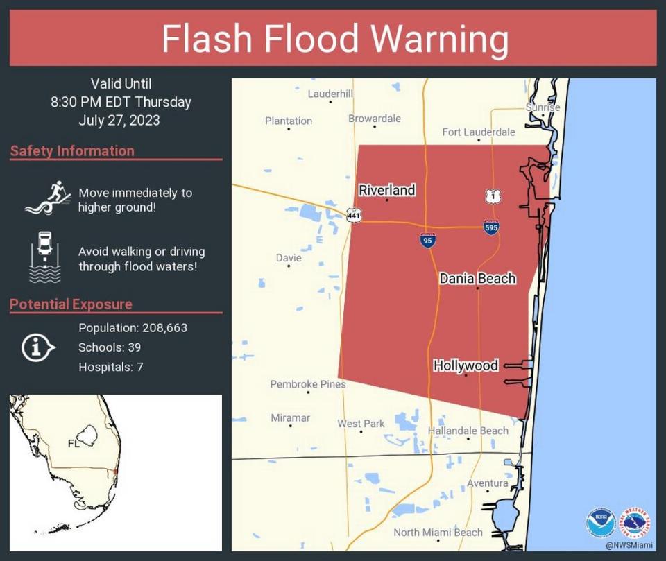
Flash flood warning in Broward as South Florida flood watch persists, rain pours down
Some good news for South Florida weather watchers: No daily heat advisories from the National Weather Service for the first time in more than three weeks.
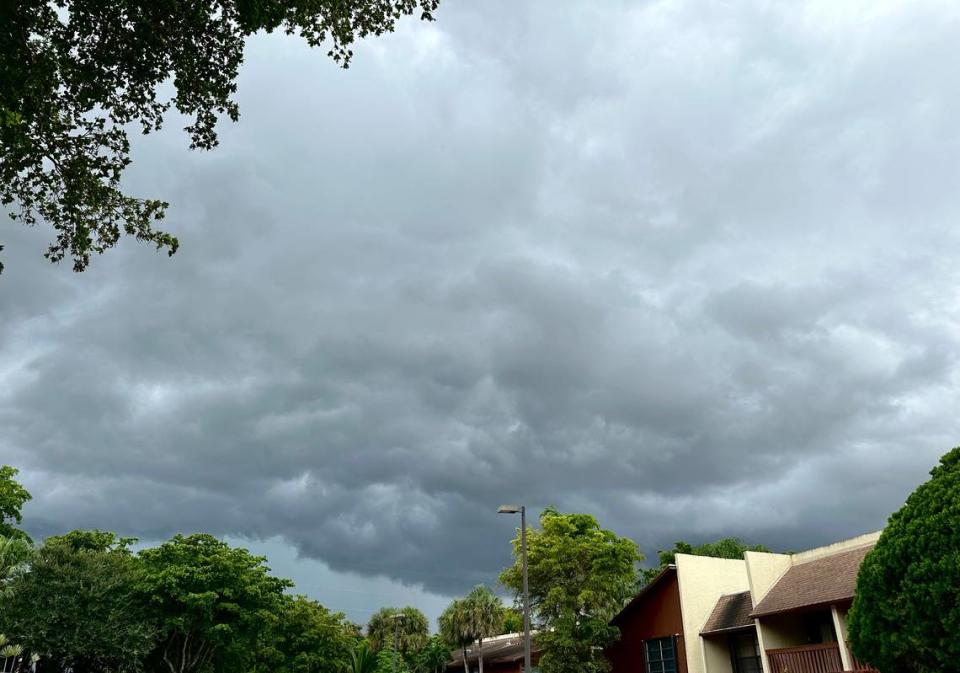
However, there’s troubling news too. Torrential downpours have triggered flash flood warnings and flood watches across South Florida — prompting forecasters to advise residents in low-lying areas to seek higher ground.
Flash flood warning issued
The flash flood warning affects certain cities and neighborhoods in coastal Broward and lasts until 8:30 p.m.
Forecasters say substantial rainfall inundated roads and cars were left stranded due to thunderstorms bringing down heavy rains. About two and three inches have fallen, with an additional two to three inches possibly on the way.
The areas specifically under the warning include: Fort Lauderdale, Hollywood, Davie, Plantation, Hallandale, Dania Beach, Fort Lauderdale-Hollywood International Airport, Port Everglades, Melrose Park, Broadview Park and other surrounding areas.
Flash flooding is expected to be seen in small creeks and streams, highways, underpasses, streets and other poor drainage areas.
On top of that, flooding completely shutdown the Henry Kinney Tunnel along U.S. 1 in Fort Lauderdale for a moment, police said. Some cars were stranded but the tunnel is now passable for motorists.
#Update - The tunnel is passable at this time. Please drive safely. @FLFR411 @FTLCityNews
— Fort Lauderdale Police (@ftlauderdalepd) July 28, 2023
Over at the Fort Lauderdale-Hollywood International airport, the entrance to the arrivals and departures levels from East Perimeter Road were temporarily closed around 6:30 p.m.
About two hours later, those entryways reopened. Though the intersection of Griffin Road and South Perimeter Road by the airport remains flooded.
#WeatherAlert: Due to heavy rainfall, the entrance to #FLL’s arrivals/departures levels from East Perimeter Road (near the Cell Phone Waiting Area) is temporarily closed because of flooding. Motorists are advised to use alternate entrance routes into the airport.
— Fort Lauderdale-Hollywood Int'l Airport (FLL) (@FLLFlyer) July 27, 2023
Residents are advised to turn around when approaching a flooded area.
“Be especially cautious at night when it is harder to recognize the dangers of flooding,” forecasters said. “Be aware of your surroundings and do not drive on flooded roads.”
Flood watch, too
Since Wednesday, storms have dumped several inches of rain throughout South Florida, prompting a flood watch to be issued for the region.
The National Weather Service in Miami says the watch will be in effect until Friday morning. The advisory covers all of Miami-Dade County, coastal and metro Broward and Palm Beach counties.
The first visible frames of the strong tropical wave to our east is bringing abundant cloud cover and moisture to South Florida. Elevated rain chances today and tomorrow; keep an umbrella handy! #FLwx pic.twitter.com/SNZLfZb0pK
— NWS Miami (@NWSMiami) July 27, 2023

Meteorologist George Rizzuto says, “There’s a weak kind of tropical wave disturbance pushing toward our area, so it’s increasing the moisture and chances for showers and storms the next few days.”
The weather service notes that the watch, which warns of the potential for flooding, was issued “due to the grounds being very saturated.”
Heavy showers rolled through Broward, West Miami-Dade and the Upper and Middle Keys early Thursday, said CBS News Miami meteorologist Lissette Gonzalez.
“The roads are drenched,” she said. “It is a mess.”
A funnel cloud was spotted offshore of The Breakers in Palm Beach Thursday afternoon, WPBF 25 News meteorologist Brooke Silverang shared with the weather service on Twitter.
Funnel cloud just offshore from the Breakers on Palm Beach. @NWSMiami @WPBF25News pic.twitter.com/HbZrwyu9G6
— Brooke Silverang (@WPBF_BROOKE) July 27, 2023
And more rain is in the forecast.
The National Weather Service has placed most of #SouthFlorida under an elevated risk of HEAVY RAINFALL today with the potential for flooding. Some roads are already flooded and dangerous. Give yourself extra time for your commute this Thursday morning @CBSMiami pic.twitter.com/NhgXGcddCN
— Lissette Gonzalez (@LissetteCBS4) July 27, 2023
MORE: Hurricane center tracking new wave in the Eastern Atlantic. What the forecast says
Forecast through the weekend

Gonzalez forecasts more rain in the afternoon and evening, as much as six inches in some spots. The chance of rain on Thursday was 80%, according to the weather service.
More rain is expected on Friday and the flood watch could be extended, Gonzalez also said.
Though still around 90 in the early afternoon, the lack of a heat advisory has been felt.
Kind of.
Thursday started with a cooler feel, with temperatures in the upper-70s. The weather service forecasts an afternoon high of 89 in South Florida, which will feel like 101 when you add the humidity.
The heat and humidity will increase Friday and into the weekend, the weather service said in a briefing Thursday afternoon.
Traveling?
If you’re hitting the roads for the weekend, the drive may not be pleasant. Here’s what you need to know.
▪ Florida Keys: Scattered showers and thunderstorms are forecast Thursday through Tuesday, with the wettest odds on Thursday and Friday at 60%, before settling into a 40% pattern Saturday through Tuesday. No flood or heat advisories are in effect as of Thursday afternoon for the Keys, where the forecast calls for low- to mid-90s.
▪ Orlando: That disturbance off the Atlantic is messing with Central Florida’s attractions. Scattered to numerous rain and lightning storms are forecast to move inland Thursday and last through Wednesday. Some of these storms — a 70% chance most days — could bring one to two inches of rain, frequent lightning, gusty winds of 35 to 50 mph, and torrential downpours, the weather service in Melbourne said. Highs will be in the low-90s.
▪ Tampa Bay: The tropical wave increases the region’s rain and storm chances to 80% in afternoons and evenings, according to the Tampa Bay Times. Rain chances decrease Monday.
▪ Sanibel and Captiva: The rebuilding islands will also see elevated rain and storm chances from 80% Friday through 70% into early next week, according to the weather service.
▪ Gainesville: Friday and Saturday will be the wettest days with rainfall amounts of a tenth to a quarter inch expected on those days and an 80% chance. The unsettled weather remains 50% or higher through Wednesday.