
Bryan Norcross: Category 5 Hurricane Beryl racing through Caribbean Toward uncertainty in Gulf
Updated at 9 a.m. ET Tuesday
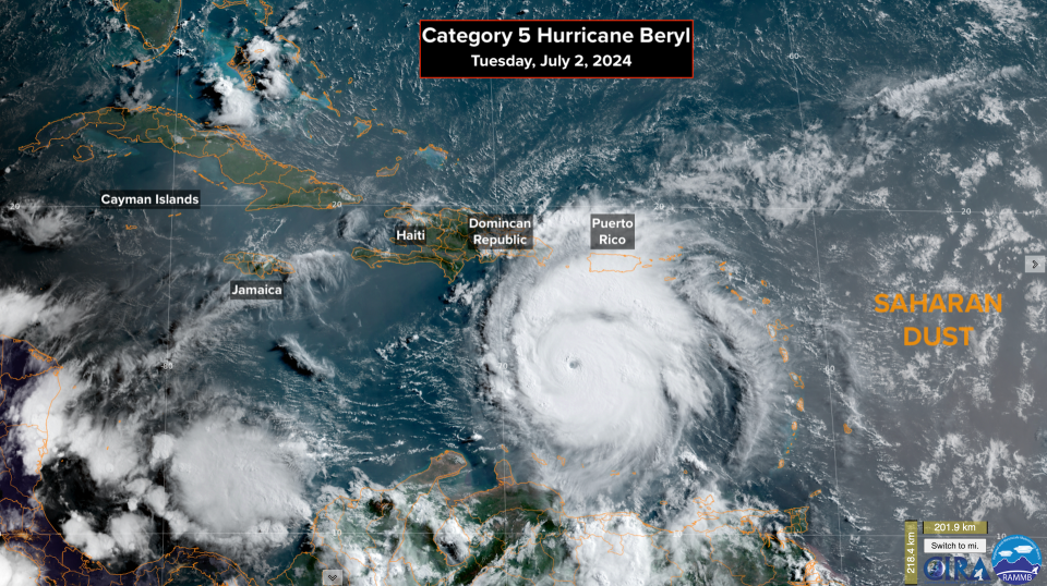
Hurricane Beryl has blown the roof off the record book. It's an unprecedented type of storm for this time of year. Ocean water temperatures and the atmospheric pattern are what we typically find at the peak of the hurricane season, and Mother Nature has delivered a September-like ultra-intense storm in July.
Tropical downpours will blow across Puerto Rico on Tuesday from the outer bands of Beryl, which is well to the south. The south coasts of the Dominican Republic and Haiti will take a harder hit because Beryl’s center will be closer. Tropical-storm conditions are expected there.
The atmospheric pattern over the central Caribbean is predicted by the computer forecast models to slowly become more hostile. The National Hurricane Center's forecast of slowly decreasing intensity beginning later today reflects the anticipated less-supportive environment. There are no abrupt changes forecast, however, so Beryl is expected to continue to be a powerful and dangerous hurricane for at least the next two days. Even if it's not a Category 5, it will likely grow in size, so its strong winds will affect a wider area.
Jamaica and the Cayman Islands are on the right side of the cone, which is where the strongest winds in the circulation will likely occur. Everyone on those islands should stay informed of the latest information and instructions. Hurricane watches and warnings have been issued.
There is high confidence that Beryl will track through the Caribbean, so there is no threat to Florida or the surrounding areas.

The questions arise late Thursday or Friday as the storm approaches Mexico's Yucatán Peninsula. Beryl will presumably be a weaker storm at that time due to atmospheric factors and possible interaction with the tall mountains on Jamaica. The water in the Caribbean is extraordinarily warm, however, so it might regenerate quickly. This adds up to high uncertainty about Beryl's strength when it approaches the Yucatán.
Since the track is forecast to be a little farther north through the Caribbean than yesterday's forecast, there is reasonable certainty now that Beryl will track across the Yucatán into the Gulf. Its forward speed will be slowing at that point since the steering high-pressure system to the north will be moving away.
It increasingly appears that Beryl's track will bend north in the Gulf, but the sharpness of the bend is unknowable. The future track is dependent on the strength of Beryl, how far north it is late in the week, how fast it gets to the Gulf, and the exact position of blocking high-pressure to the north.
The National Hurricane Center is preliminarily forecasting a tropical storm in the Gulf, but adding the admonition that the intensity is highly uncertain. An intensifying hurricane is not out of the question.
On the current schedule, Beryl will be in the Gulf over the weekend. Everyone in the western Gulf, including on the Texas and Louisiana coasts, should plan to stay informed.
The system we've been watching, officially called Invest 96L, is not getting organized. Saharan dust is wrapping around it, and the upper-level winds ahead on its track are forecast to become quite hostile.
The National Hurricane Center is now giving it a low chance of becoming even a tropical depression.
The current forecast favors the disturbance moving through the eastern Caribbean islands tomorrow. It's most likely that this system will track north of the islands of the Grenadines that were devastated by Beryl.

There is no indication that this will be a strong system, but gusty squalls with heavy rain are possible. The moisture surge will likely pass over Puerto Rico and the Virgin Islands on Thursday.
The long-range computer forecasts show the tropics calming down next week. But as we've seen, surprising things can happen when ocean temperatures are as warm as they are this year.
Original article source: Bryan Norcross: Category 5 Hurricane Beryl racing through Caribbean Toward uncertainty in Gulf

