
Eastern Ontario to bear the brunt of the heaviest snow with this storm
Freezing rain warnings, winter storm watches and special weather statements all line Ontario, as the week is set to end with a messy mix of rain, ice and a swath of heavy snow.
Precipitation types and amounts will depend heavily on location.

A Colorado low will track just south of the border late Thursday through early Friday bringing a widespread rain to much of southern Ontario Thursday afternoon, before changing to snow by Thursday night and into Friday morning. Intermittent freezing rain is also possible as temperatures hover around zero through the first half of Thursday, with untreated surfaces such as roads, walkways and parking lots becoming icy or slippery at times.
Between 20-30 mm of rain is expected for the Niagara region, with closer to 5-15 mm for the Greater Toronto Area (GTA). Localized ponding and pooling is possible on grounds that are still partially frozen.
The change over to snow will occur through the overnight and pre-dawn hours on Friday for Toronto, Niagara, and southern portions of the GTA.
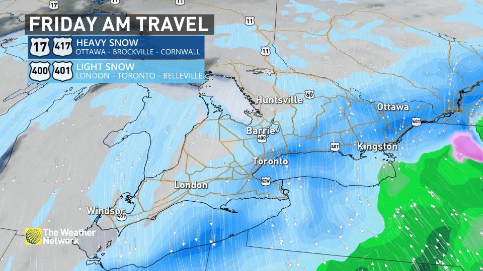
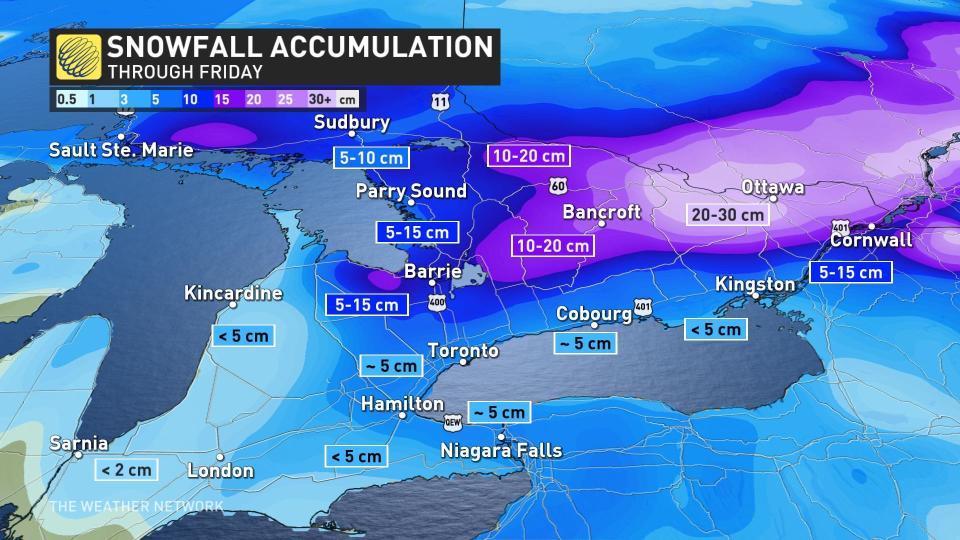
Around 5 cm of snow is expected across the GTA and sections of southwestern Ontario, which could threaten a slick Friday morning commute.
SEE ALSO: Newfound comet not seen for 50,000 years will soon swing by Earth
The heaviest swath of snow however, will fall across parts of cottage country, most of eastern Ontario and into southern Quebec with this system.
Between 5-15 cm of snow is forecast for areas east of Georgian Bay, including Muskoka and Huntsville, with Bancroft forecast to see closer to 10-20 cm. For the city of Ottawa, 20-30 cm of snow is possible.
The snow will intensify Thursday evening and will continue into Friday afternoon, with difficult travel conditions possible amid reduced visibility in heavy snow.
"Avoid travel in possible," urged Environment and Climate Change Canada (ECCC) in the winter storm watch posted for the Ottawa region.
The system will move out of the province and into Quebec by Friday afternoon, with all snow departing with it by Friday evening.
WATCH: Hidden icy danger present across Ontario through Friday
Sunshine finally arrives behind this system
In a new year that's only seemed to have brought grey skies and cloud cover, sunshine will finally grace the region this weekend -- though with temperatures remaining slightly below seasonal. Daytime highs will quickly rebound above seasonal again next week, dominating through at least January 20.
An active pattern will continue next week and beyond, with a few more Colorado lows tracking into the region every few days. Because of the milder pattern, rain appears to be more likely for southern areas, but significant snow would be expected well north of the storm track.
For more forecast information and updates, keep checking back to The Weather Netowork.

