
Hurricane Teddy projected to bring nasty weather to parts of N.L. Tuesday
More nasty weather is on the way, projected to blanket parts of Atlantic Canada Tuesday into Wednesday as Hurricane Teddy continues to move north near Bermuda.
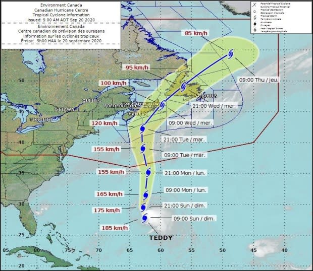
By the time the storm reaches Canadian waters it will be a category one hurricane, but is expected to be downgraded to a "very dangerous post-tropical storm" as it reaches land, according to an Environment Canada statement Sunday afternoon.
The issued advisory specifically mentions Burgeo-Ramea, the Burin Peninsula, Channel-Port aux Basques and vicinity and the Connaigre Peninsula as potentially affected areas of the province.
CBC meteorologist Ashley Brauweiler said rain should begin Tuesday evening, with the majority landing on the southwestern portion of the island. Approximately 50 millimetres can be expected.
Winds will begin to pick up on Tuesday as well, but the strongest winds for southwestern Newfoundland will be Wednesday evening. Gusts could reach 100 km/h, and stronger again in the Wreckhouse area based on the current track. Power outages, if any, should be confined to the south west.
Environment Canada said most regions will see some tropical storm force winds.
"Power outages are likely due to breaking branches and possible tree falls, especially due to trees still having their full foliage. Every effort should be made to secure temporary structures," reads the weather advisory.
Storm surge likely
Environment Canada is also projecting a storm surge with large waves building in Atlantic waters near the south coast on late Tuesday.
The worst waves are expected for Wednesday.
"The highest risk is the combination of the very large waves combining with the storm surge to cause dangerous conditions along the Atlantic coasts of Nova Scotia and Newfoundland, with rough and pounding surf, localised flooding and coastal erosion," the weather advisory reads.
Brauweiler said a storm surge and waves will be a concern along southern Newfoundland.
Forecast models are pointing at six to nine metre waves at this point between Tuesday and Thursday, she said.
Meteorologist Bob Robichaud of the Canadian Hurricane Centre will provide an update to members of the media on Hurricane Teddy at 1 p.m. on Monday.
Read more articles from CBC Newfoundland and Labrador
