
Idalia set flood record for Cedar Key. Rising seas only raise future risks for Florida
People have lived on Cedar Key for hundreds of years, returning and rebuilding after Civil War battles, fires and most often after flooding from storms and hurricanes.
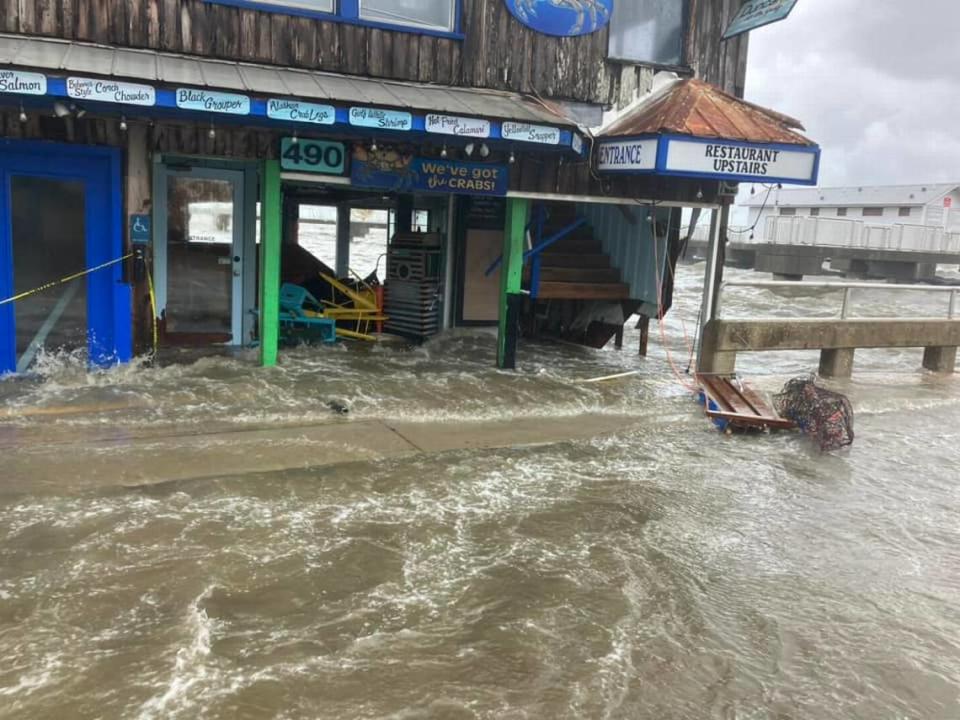
And they’ll probably do it again after the damaging passage of Hurricane Idalia, a major Category 3 hurricane that brought nearly seven feet of storm surge Wednesday morning to a small community famed for its great fishing, rich wildlife and “Old Florida” character.
It was a record inundation, filling the small waterfront city’s main streets and flooding older unelevated buildings. It was also a glimpse of the threat that much of low-lying coastal Florida faces from rising seas that will increase tidal flooding and hurricanes like Idalia that will bring higher levels of surge.
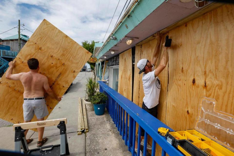
Tiny Cedar Key, permanent population of about 700, is high on the list of state’s most vulnerable coastal communities. The damage from Idalia has not yet been calculated but TV and live stream broadcasts showed floodwaters engulfing homes, hotels and buildings that had not been previously elevated. Some will have to be gutted or razed and rebuilt, likely on stilts. Even the one low-lying road that leads to the village on the Gulf of Mexico is at increasing risk and will have to be raised in the future.
Cedar Key has recorded the fourth-highest rate of sea level rise acceleration in the nation, according to the National Oceanic and Atmospheric Administration. Local sea level has risen nearly six inches since 1992, hard to see on a daily basis but a big difference when storm surge is added on top. Erosion of shorelines also has led to a loss of recreational areas. There are a lot reasons why Jim Cantore, the Weather Channel storm tracker famous for field reporting in severe storms, decided to ride out Idalia in Cedar Key.
The historic downtown area with city hall and the water wastewater treatment plant system are some of the lowest, most vulnerable assets on the island. Another part of the island that badly flooded was Dock Street, an area with restaurants and gift shops alongside the pier that is popular with tourists.
Live w/ @JimCantore in Cedar Key, FL on @weatherchannel where the storm surge is at 6+ ft and rising from #HurricaneIdalia pic.twitter.com/zE7aS30E4T
— Steve Petyerak (@StevePetyerak) August 30, 2023
Most recently in 2016, Hurricane Hermine flooded the historic downtown district with six feet of storm surge that inundated roads and flooded city hall.
“It took them like two years to rebuild and it was nice, but they were not able to raise it above their flood zone,” Kathryn Frank, associate professor in the urban and regional planning department at the University of Florida said in an interview with the Miami Herald.
Impacts of climate change on the island are already noticeable to Frank, who studied sea level rise at Cedar Key. During community outreach events, she heard stories about dry land turning into marsh or and saltwater intrusion killing off swaths of palm trees.
“The community lives with the understanding that everything could change very quickly with a storm,” Frank said.
A history of hurricanes
Cedar Key, located amid wildlife and nature preserves about 50 miles southwest of Gainesville, has a long history with storms and hurricanes.
Archaeologists have documented centuries of occupation by indigenous people, who left behind shell mounds and other tell-tale material . Until 1896, the pioneer community was centered on a small island nearby called Atsena Otie that operated a pencil factory that harvested local cedar trees. That area was abandoned after hurricanes left the place inhabitable and moved to where the city of Cedar Key is now.
Being all too familiar with storm damage, the community rebuilt and raised buildings and homes. But about seven miles from downtown Cedar Key in more rural areas of Levy County, people who live in mobile homes and use septic systems and personal wells are most at risk from the effects of flooding and salt-water intrusion.
Cedar Key has been the subject of a few studies on sea level rise. The Army Corps of Engineers predicts up to 1.5 feet of sea level rise in Cedar Key by 2050. Between 1983 to 2008 — just 25 years — the sea submerged 840 acres of dry land, USA Today reported in 2017.
Preserving history as water encroaches
In a collaboration between the City of Cedar Key and the University of Florida, Frank led the project for the flooding vulnerability assessment called “Resilient Cedar Key” funded by the Florida Sea Grant.
Since Hurricane Hermine — which also brought a devastating six feet of surge — Cedar Key focused on building back with funding from state and federal projects. Because Cedar Key is a small community, funding isn’t easy to secure, Frank said.
“They’re small communities competing with larger communities for funding,” Frank said. “Somebody doing a cost benefit analysis might say it would cost them votes, and in small communities there’s a limited amount of staff that is available to be persistent with grants.”
Though small in population, Cedar Key gets a lot of visitors — an estimated 300,000 people visit each year drawn to the nature preserves, recreational fishing, shellfish and historic sites.
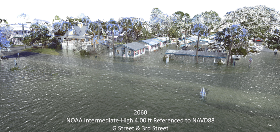
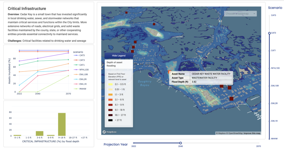
To engage the community on the risks their town could face, and inform them on what historic sites face the most risk, The UF researchers created an interactive map based on NOAA sea level rise scenarios. The tool toggles between different storm and tide scenarios. For example, you can explore flooding depths for a Category 3 hurricane and see 3.82 feet of flooding for the Cedar Key wastewater facility at 2040 sea levels using the sliders.
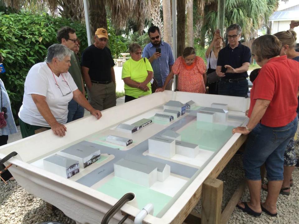
Using 3D laser scan images of the streets, they then animated what varying levels of sea level rise could look like in the future. They replicated the downtown area in a physical model.
In 2040 projections, the 1950’s Faraway Inn is expected to be impacted by sea level rise in Cedar Key. By 2100, another 42 historic sites could be inundated.
Resilience projects built in the last several years will be put to the test during Hurricane Idalia. Living barriers like oyster reefs were restored, electric lines were buried and water pipes were removed from bridges to prevent saltwater intrusion in the drinking water. The C Street Bridge, which connects with Dock Street at the Cedar Key Fishing Pier on the Gulf of Mexico, had a 6.7 million dollar renovation to be raised 3 feet. Its purpose is to provide an easier evacuation during severe storms.
According to a Headwaters Economics Neighborhoods At Risk stormwater tool that Cedar Key used to create their plans, nearly 60 percent of properties are vulnerable to flooding during storms.
“It’s really a mindset to not only take coastal hazards seriously, but to understand that they’re going to become more frequent and intense with climate change and to take any opportunity to work that understanding into their projects and policies,” Frank said.
This climate report is funded by the Lynn and Louis Wolfson II Family Foundation in partnership with Journalism Funding Partners. The Miami Herald retains editorial control of all content.

