
Ingredients aligning for severe storm, tornado risk in Central Canada
Thursday’s busy travel day ahead of the long weekend will likely be impacted by thunderstorms for much of Ontario and Quebec.
Storms are expected to turn severe for many areas, with the threat for tornadic activity over the Ottawa region and its neighbouring areas in Quebec on Thursday afternoon and evening.
DON'T MISS: Summer’s muggy heat surges and wanes across Canada this August
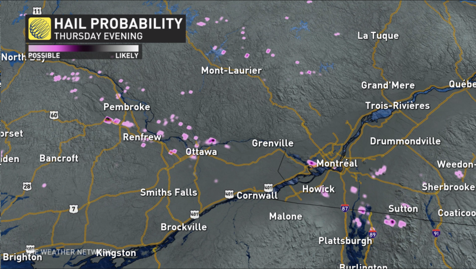
Large hail and heavy rainfall will also accompany the multiple rounds of storms expected ahead of the August long weekend, so it'll be important to stay weather-aware and heed any warnings issued in your area. Also keep your electronics charged and have a safety plan in place.
Thursday
Areas: Much of Ontario and Quebec
Timing: Thursday afternoon and evening
Weather: Ottawa, Gatineau and surrounding regions are at the forfront for all hazards, including supercell and tornado potential into the afternoon and evening.

We will see a round of morning showers, but the environment picks up steam into the afternoon and evening hours. Severe storms are possible along the Highway 401 corridor east of Toronto heading all the way into Ottawa. Additionally, this will be possible on Highway 400 north, cottage country, Algonquin and all the way into Sudbury.
This widespread risk will affect many routes with large hail, up to golf ball-sized, and heavy downpours being the primary hazards.
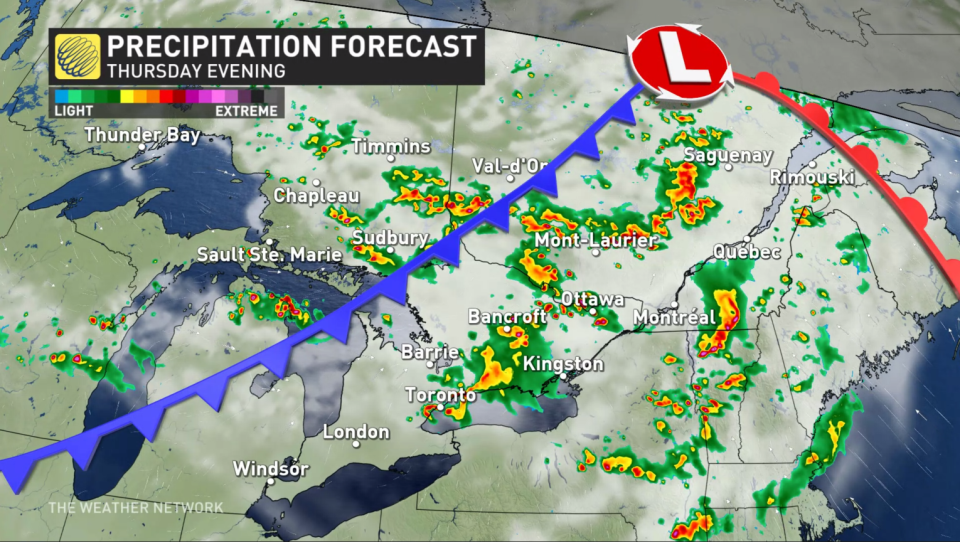
Forecasters are closely watching a potent environment around the National Capital Region and eastern Ontario, spanning into southern Quebec, where one or two tornadoes may also be in the cards. Supercells are possible around the 4-7 p.m. hours when instability and thunderstorm energy are the highest, triggered by a cold front cutting through the region.
Confidence: High for severe thunderstorm activity, lower for tornadoes and exact timing of supercells
Keep your electronics charged and have a safety plan in place as weather watches and warnings update throughout the day. Expect to drive slowly and leave extra time if a thunderstorm pops up along your route.
WATCH: Nickel, golf ball, baseball; what these hail sizes mean for damage
Camping this long weekend? Check out The Weather Network's Camping Guide before heading out!
Prepare
Make sure to keep up-to-date on your local forecast information and alerts. If you are outdoors in an area with a severe weather threat, make sure you have a safety plan in place in case you need to get to shelter.
If a severe thunderstorm approaches your location, remain mindful of trees or tree limbs that loom near your home. Trees falling into buildings are a significant source of injury during strong storms. Try to avoid rooms where trees may cause damage during high winds.
The greatest danger in any thunderstorm is lightning. If you can hear thunder, you’re close enough to be struck by lightning.
DON'T MISS: Watch? Warning? How we communicate severe weather in Canada
WATCH: Camping and severe weather, make sure you have a plan
Stay with The Weather Network on all platforms for the latest on conditions across Ontario and Quebec.

