
Severe storm risk, extreme heat continues through Thursday over the Prairies
The hot and humid weather continues to fuel a multi-day severe weather risk across parts of the Prairies this week, with the threat for strong winds and very large hail on the table reappearing to close out the work week.
The risk will span all three Prairie provinces on Thursday, with the chance for heavy rain, strong winds, and very large hail where storms develop.
DON'T MISS: 10 ways The Weather Network app can help you plan for summer weather
Meanwhile, heat warnings continue to cover much of the region, as well, with Environment and Climate Change Canada advising folks to take precautions to protect themselves, their families and their neighbours.
The heat will relax somewhat and shift east late week, with a shot of much cooler weather expected for northern areas late week, and into the weekend across the south. This will be followed by more heat for next week.
Heat continues as storm threat increases for Thursday

People using misting stations at the Calgary Stampede to help cool down. (Connor O'Donovan/The Weather Network)
RELATED: What is 'humidex' and how does it impact our bodies?
Temperatures in Edmonton on Wednesday reached 36.2°C, making it tied for the fourth hottest day in recorded history, and second warmest July day since the city's records began in 1880!
To put it into perspective, the second-warmest temperature on record occurred in 2021 during the heat dome, when Edmonton reached 37°C.
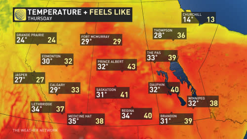
Temperatures will begin to dip a slightly compared to Wednesday across much of Alberta, with the exception being the southeastern portion of the province.
Across central and southern Saskatchewan and Manitoba, the humidex will have things feeling closer to 40 by Thursday.
Thunderstorm risk continues Thursday and Friday
With the extreme heat comes the storm risk, as well. Thunderstorms will reappear in the forecast Thursday as the "ring of fire," the northern edge of the heat dome, will set up in the area. Because of the excessive heat generated and radiated by the heat dome, storms along its boundary can be severe, as they tap into the extreme heat.
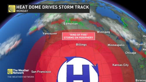
Ring of fire explainer (The Weather Network)
As the trough pushes into southern Saskatchewan, some of Wednesday's overnight storms could persist into early Thursday morning.
Through Thursday, there's a better chance of severe storms to develop across Saskatchewan and northern Manitoba. The heat dome south of the border will hinder storms from developing in southern Manitoba, however.
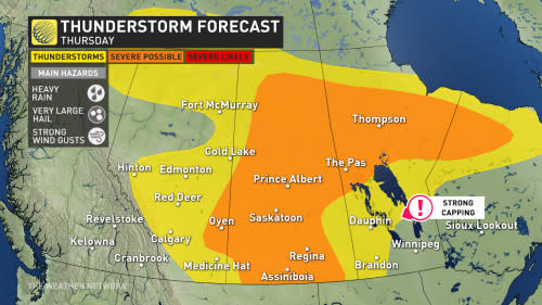
The main risk in southern Saskatchewan on Thursday will be strong wind gusts, while the main risk for northern Saskatchewan and Manitoba will be large hail.
Currently, computer models are also hinting at isolated severe storms crossing the QE2 in Alberta between Red Deer and Calgary Thursday evening and overnight.
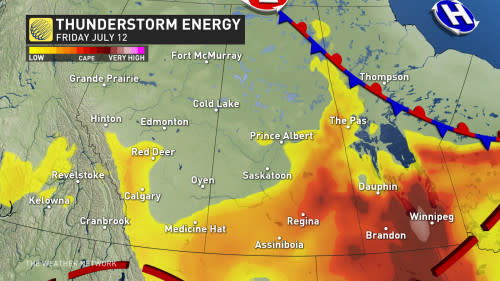
The storm risk will also linger into Friday, with the most thunderstorm energy building throughout southern Manitoba and parts of southern Saskatchewan.
Stay tuned to The Weather Network for the latest forecast updates across the Prairies.

