
Heavy rain and ‘life-threatening flooding’ hit South Florida, prompting the governor to declare an emergency
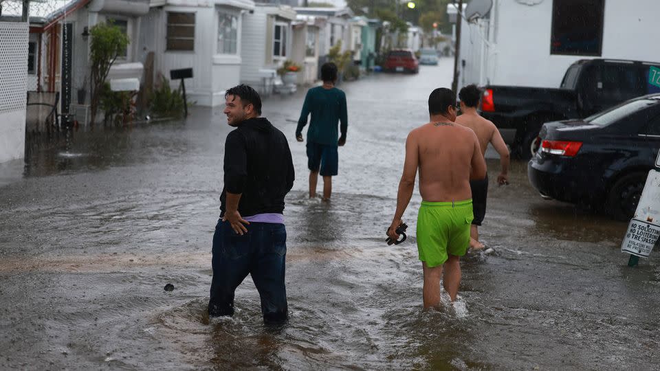
Multiple communities across South Florida — including the Miami and Fort Lauderdale areas — flooded Wednesday amid bouts of torrential rain that prompted the state’s governor to declare an emergency and stranded drivers across the region.
Flood warnings are in effect Wednesday night for parts of Broward, Miami-Dade, Collier and Hendry counties through Thursday morning, according to the National Weather Service, which warned “life-threatening flooding” was ongoing. Flood watches were also extended for Miami and Fort Lauderdale until Friday evening.
“Many areas are inundated with water w/ stalled cars & more rainfall is on the way,” the weather service said Wednesday night. “Stay off the roadways if possible.”
Footage on social media showed water levels in the area reaching to vehicles’ windows and filing up parking decks and neighborhood streets.
In Miami, video showed stranded cars that were nearly entirely submerged under water. It’s the second consecutive day the Miami area has faced down flooding issues. Storms dropped 2 to 5 inches of rain and flooded streets Tuesday.
In Hallandale Beach, where footage showed one man kayaking among cars as high waters flooded parts of the city, officials urged residents to shelter in place and avoid driving or walking through the water.
Hallandale Beach officials said a family lost their son during the storm, but were later reunited with the help of local police who were able to find the young boy.
A woman who was driving to work said she spent five hours stuck in her car along Hallandale Beach Boulevard and US Route 1 because of the flooding.
“The lights were out at multiple intersections and there were already cars that were stalled and abandoned. I’ve never seen it like that,” Hollywood resident Kait Madrigal told CNN.
Along with the heavy rainfall, the storm system also brought an EF1 tornado Wednesday to Hobe Sound, located in Martin County about 35 miles north of West Palm Beach, a National Weather Service damage survey confirmed.
Florida Gov. Ron DeSantis declared an emergency for Broward, Collier, Lee, Miami-Dade, and Sarasota counties, writing the heavy rain and floods has affected the “operational capability of critical infrastructure,” including major interstates, roadways, schools and airports.
The severe weather also forced school officials in Broward County to postpone the demolition of the Marjory Stoneman Douglas High School building where a gunman killed 17 people in 2018 to Friday.
Collier County School District officials announced that summer school and child care programs will be closed Thursday “due to the abundant rain causing localized flooding.”
“Flooding at bus stops and on streets causes hazardous conditions for student and staff transportation,” the district said on its website.
A month’s worth of rain in one day
Fort Lauderdale Mayor Dean Trantalis declared a local state of emergency, citing “excessive rain” and flooding. City officials said the heavy rainfall led to “high water” on roads across the city, adding emergency management staff were deploying high water vehicles and vacuum trucks in the area.
Trantalis urged residents to remain off the streets as they continue to pump out the standing water.
The city saw a preliminary rainfall total of roughly 9.58 inches Wednesday, making it Fort Lauderdale’s eighth wettest day on record, according to data from the National Weather Service.
“Early afternoon is when everyone was let out early from work to get home before the rain started,” Trantalis told CNN. “The streets were jammed. Instead of being flooded with water, they were flooded with cars.”
That preliminary rainfall total is also just above Fort Lauderdale’s average June rainfall of 9.55 inches – meaning the area saw over a month’s worth in one day. The total is still lower than the rainiest day in the city’s history in April 2023, when around 2 feet of rain in a 24-hour period caused severe flooding.
Heavy rainfall over the last 48 hours totaled about 12.8 inches, making it the ninth wettest two-day period for the city.
The severe weather led to over 600 flight cancellations and delays across two of the region’s main airports. At least 334 flights in and out of Miami International Airport were canceled and there were more than 287 flights canceled in and out of Fort Lauderdale-Hollywood International Airport.
While the state is no stranger to drenching rain, heavy rain events are getting even heavier as the world warms due to fossil fuel pollution. The daily downpours are also being fueled by a firehose of tropical moisture from parts of the Caribbean funneling straight into South Florida along a front draped over the state.
Several more inches of rain are expected through the rest of the work week from a broad and disorganized area of storms stuck over the state. By late week, the National Hurricane Center gives the storms a low chance of organizing into the first tropical depression of hurricane season as it moves off the Southeast coast.
Double-digit rainfall totals are likely in parts of Florida by Friday, but a few areas in southwest Florida could approach 20 inches. The southwestern Gulf Coast of the state, from Sarasota to Everglades National Park, is at the greatest risk for rainfall totaling 10 inches or more.
But bursts of intense rain outside of the highest risk areas could cause flash flooding, especially in urban or poor-drainage areas.
Flood watches are in effect for more than 8 million people in South Florida Wednesday through Thursday night at the earliest.
Gulf moisture continues to stream over South Florida, where the Weather Prediction Center has issed a level 2 of 4 flood threat overnight Wednesday, Thursday and Friday. An additional 3 to 6 inches of rainfall is expected to fall across Southeastern Florida, including Miami and Fort Lauderdale, through Friday. Rainfall storm totals over a foot are possible across much of South Florida, which is equivalent to over a month to several months’ worth of rainfall.
The flood risk will increase through the week as storms unload drenching rain over the same area day after day, causing rainfall totals to climb, soils to saturate and area waterways to swell.
If there’s any silver lining, it’s the rain will be beneficial to areas suffering through drought. Half of Florida is experiencing abnormal dryness or drought conditions, with the worst drought centered in the bull’s-eye for the heaviest rain, according to the US Drought Monitor.
How a giant gyre of moisture leads to tropical trouble
The robust moisture fueling this week’s storms typically pools over parts of the Caribbean Sea and the southern Gulf of Mexico at this point in the season into the Central American gyre: A large, disorganized area of showers and thunderstorms that rotates over Central America and its surrounding waters.
The gyre’s broad spin and deep moisture can help tropical systems form in parts of the Caribbean, the Gulf of Mexico and even the extreme eastern Pacific when other necessary factors – including favorable upper-level winds and warm ocean water – align.
The gyre typically first develops around the late spring and early summer, which is one reason most June tropical systems form in the Gulf of Mexico or off the East Coast of the US.
Despite plenty of bathtub warm water in the Caribbean and the Gulf of Mexico, upper-level winds, known as wind shear, are much too disruptive right now for any tropical systems to form in these areas, according to Jon Rizzo, a meteorologist with the National Weather Service in Key West, Florida.
What the gyre is doing, is juicing up the wet weather across the Gulf Coast, like what Florida will endure this week.
“Just the mere presence of the Central American gyre forming tells us that summer is here and the rainy season is about to begin,” Jon Rizzo, a meteorologist with the National Weather Service in Key West, Florida, told CNN.
June, July, August and September are generally the wettest months of the year for much of Florida. Frequent surges of deep, tropical moisture and the direct impact of tropical systems send rainfall totals skyrocketing during this part of the year.
CNN’s Sharif Paget, Robert Shackelford, Taylor Galgano, Melissa Alonso and Jamiel Lynch contributed to this report.
For more CNN news and newsletters create an account at CNN.com

