
Pattern change brings cool, wet weather to the Prairies and B.C.
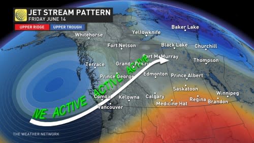
An upper-level low pushing onto the B.C. coast will support several surface lows across western Canada, bringing the risk of showers and thunderstorms throughout the weekend.
The low will bring cooler temperatures to the region, prompting the risk of high elevation snow for parts of B.C. and Alberta.
Rainfall will be widespread across B.C. and the Prairies throughout the weekend
Friday: heavy rainfall pushes in
A cold front will push onto B.C.'s coast bringing showers throughout the day along with the risk for thunderstorms to develop along coastal and interior regions of the province.
Rain will become heavier Friday night into Saturday morning along the south coast. Northern B.C. will also see some heavy rainfall as the showers become widespread across the province.
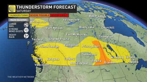
Rainfall will also spread across to Alberta and into Saskatchewan on Friday. Northern and central Alberta, including Edmonton will see the biggest risk for stronger storms on Friday afternoon and evening. The greatest threats for these storms will be large hail, strong wind gusts, and heavy rainfall.
Regina and parts of southern Saskatchewan will not miss out on the fun either. Strong thunderstorms will roll through the region mid afternoon through the evening.

Saturday and Sunday: Storms continue
The widespread thunderstorm risk continues for much of western Canada, from B.C.'s south coast through to Alberta, Saskatchewan, and southern Manitoba. Vancouver, Calgary, Regina, and Winnipeg are all in line to see thunderstorm risk through much of the weekend.
A low-pressure system tracking through the SK/MB border from the United States will trigger stronger storms Saturday evening and night across southeast Saskatchewan and southwest Manitoba. These storms have the potential to be severe.
the active weather will continue across the Prairies through Sunday. Widespread, gusty wind will begin developing across the region on Sunday, bringing up to 70 km/h across southern Saskatchewan during the afternoon.
Looking ahead, the beginning of next week will be quite chilly for much of the Prairies before transitioning back into seasonal temperatures towards the end of the week.
Stay tuned to The Weather Network for more weather updates for B.C. and the Prairies.

