
Tropical Depression forms with track toward Caribbean. It could be season’s first hurricane
A tropical depression has formed in the Atlantic, and it’s on track to strengthen into Tropical Storm Beryl overnight as it barrels west. It could become the season’s first hurricane by Sunday.
Friday evening, the National Hurricane Center released its first forecast track for the depression, which called for the system to strike the Windward Islands as a Category 1 hurricane with 85 mph sustained winds late Sunday and Monday.
Officials have not yet issued watches or warnings for the storm, but the hurricane center warned that hurricane and tropical storm watches will likely be required by Friday night or Saturday morning.
As of the 5 p.m. update, tropical depression 2 was about 1,225 miles east of Barbados, headed west at 21mph, with maximum sustained winds around 35mph.
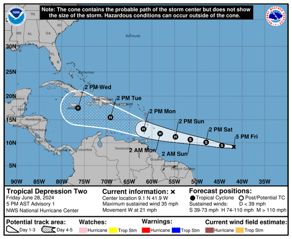
Forecasters said the depression is likely to keep moving west, through the Windward Islands and into the rest of the Caribbean, early next week, where it has a window to strengthen further into a Category 2 hurricane in a pocket of warm water and low wind shear.
“Typically, the atmospheric environment is unfavorable for intensification in this portion of the Atlantic basin in late June. However, the overall atmospheric and oceanic conditions appear conducive for steady strengthening during the next few days,” forecasters wrote in the 5 p.m. discussion.
Around Tuesday, forecasters said the storm might edge north, as the subtropical ridge above it weakens a bit, allowing the storm to rise. At this point, forecasters predicted the Category 2 hurricane could have 105 mph sustained winds.
“There is a fair amount of spread in the model guidance, especially in the day 3-5 time frame, due to differences in the strength of the ridge and the aforementioned weakness,” forecasters wrote in the discussion.
By Wednesday, the forecast track suggests the eye could be just south of Jamaica, and the storm could have weakened back down to a Category 1 hurricane.
From there, official predictions stop. The hurricane center’s cone of uncertainty does not project past five days, but global weather models, which are largely unreliable before a storm forms a solid center swirl, have suggested the hurricane could fork north, toward Jamaica and Haiti, if it is stronger, or stay lower and head toward Central America if it’s weaker. By Friday afternoon, more and more models appeared to focus on a more southern path.
“After five days, the models open up with very high uncertainty and a wide range of possible outcomes,” wrote Craig Setzer, chief meteorologist for Royal Caribbean Group, on Twitter.
“For now, the U.S. Gulf Coast & Florida will have to keep a close eye on this system as it’s too early to tell what if any impacts there will be, but impacts can’t be ruled out for late next week/weekend.”
While much of the main development region of the Atlantic is clouded with hot, dry Saharan Dust — a feature notoriously unfriendly to storms — this system is swirling just south of the cloud, in a pocket of warmer-than-average water.
Hot sea surface temperatures are fuel for storms, and the Atlantic has plenty of that this year. So much so, that NOAA called it a primary reason the agency issued a season prediction for more storms than ever before.
READ MORE: New preseason hurricane forecast is highest ever issued. Brace yourself, Florida
The Atlantic normally doesn’t get the conga-line look of tropical waves rolling off the African coast and heading west, one after the other, until the peak of the season in August and September. But on Friday, the National Hurricane Center was also tracking a tropical wave right behind the tropical depression.
The disturbance appears to be staying in the same dust-free, hot water lane.
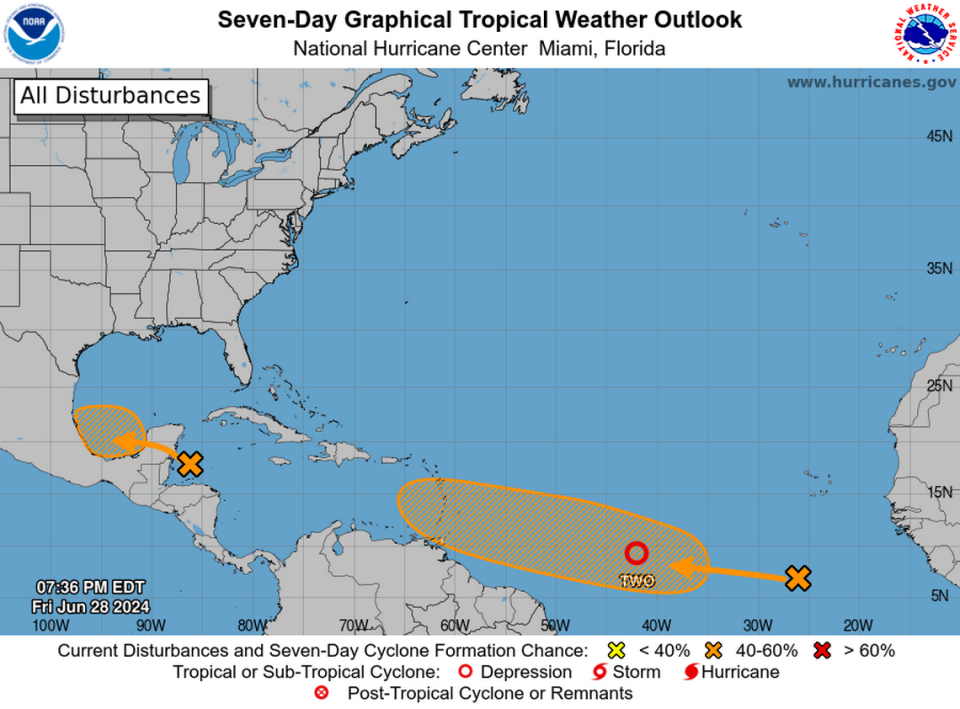
As of 8 p.m., the hurricane center gave the tropical wave no chance of strengthening in the next two days, but a 40% shot at forming a tropical depression or storm in the next week, a slight uptick from earlier in the day.
“Environmental conditions appear generally conducive for additional development of this system, and a tropical depression could form by the middle of next week while it moves generally westward at 15 to 20 mph across the eastern and central tropical Atlantic,” forecasters wrote.

